404
Oops, the page you are looking for doesn't exist.
Legacy Listings
- Active Commercial Property Farms Horse Property Hunting Land Ranches Recreational Property Development
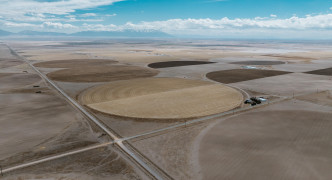
Gunbarrel, one of the largest contiguous organic farms in Colorado is now being offered for sale in the San Luis Valley. Gunbarrel Farm encompasses 6,189+/- acres of agricultural land, with 4,680 n...
$38,500,000
6189 acres
-thumb.jpg)
- Sold Farms Horse Property Hunting Land Ranches Recreational Property
It is a once in a lifetime opportunity in todays day and age that one gets a chance to buy five contiguous quarter sections of irrigated farm land directly off a state highway in Central Nebraska. ...
$4,500,000
790 acres

- Active Commercial Property Farms Acreages Development
Heading to auction, this diverse Springfield, NE property portfolio spans over 200 acres, offering a mix of residential, agricultural, commercial, industrial and development opportunities with stun...